By SANCHESKA BROWN
Tribune Staff Reporter
sbrown@tribunemedia.net
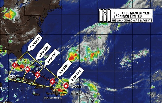
RESIDENTS in the southeast Bahamas were expected to experience pockets of heavy rain and thunderstorms last night, as a tropical wave called Invest 99L continues to move through the islands.
Deputy Director of the Department of Meteorology Basil Dean said the system is producing tropical storm-force winds, though it has yet to form a closed circulation associated with tropical storms or depressions.
He said meteorologists have discovered that the winds have “died down some” and the shower activity has become disorganised, but residents in the entire Bahamas should prepare for rain beginning today until Tuesday.
Mr Dean said regardless of tropical cyclone formation, gusty winds and heavy rain “are highly” likely to accompany this system and could result in severe flooding over the Turks and Caicos Islands and the southeast Bahamas, which includes Long Island, Ragged Island, Acklins, Crooked Island, Mayaguana and Inagua.
“There is a 50 per cent chance the system could strengthen into a tropical depression or tropical storm but that would not be until it is well out of our waters,” Mr Dean said on Thursday.
“From all indications it will rain until Tuesday and the weather will return to normal on Wednesday. Flooding is still possible and residents who live in areas that are prone to flooding should take whatever steps are necessary. Everyone will not get the same level of rain and flooding but everyone should be alert.”
Authorities advised small boats to stay in port.
The disturbance has produced tropical storm-force wind gusts between 40 mph and 50 mph in heavy squalls over some of the northern Caribbean islands and surrounding waters since Wednesday.
Nearly four inches of rain fell in the Dominican Republic yesterday and 19 of its 32 provinces were on alert as rivers rose rapidly and flooding was expected.
Earlier this week, National Emergency Management Agency (NEMA) Director Captain Stephen Russell called on Bahamians to monitor the movement of all of the active storm systems, and to “finalise plans for the remainder of the hurricane season in order to safeguard lives and protect properties.”
Capt Russell said in a statement on Tuesday that people should remain vigilant, particularly throughout September and October, which he said is “peak season for storms.” He also urged residents to check weather forecasts regularly for alerts and to ensure that their homes meet building codes to withstand hurricanes and that they have storm shutters.
If the wave becomes a storm, it will be the eighth of the year as the Atlantic hurricane season moves into peak months. The storm will be named Hermine.
Meanwhile, Tropical Storm Gaston, which weakened from a hurricane earlier yesterday, was over the central Atlantic, about 1,160 miles east-northeast of the Leeward Islands. It had maximum sustained winds of 70mph and is not forecast to make landfall.


Comments
Use the comment form below to begin a discussion about this content.
Sign in to comment
Or login with:
OpenID