By SANCHESKA BROWN
Tribune Staff Reporter
sbrown@tribunemedia.net
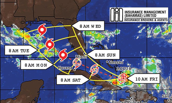
TROPICAL wave 'Invest 99L' will not produce as much rain and wind over the southeast Bahamas as was originally predicated, Deputy Director of the Department of Meteorology Basil Dean said Friday.
In an interview with the Tribune, Mr Dean said the tropical wave has made a turn toward the west and is struggling to develop into an organised storm.
U.S. Air Force Hurricane Hunters found tropical-storm force winds on Thursday but as circulation has not fully closed, it has not been classified as a tropical depression or tropical storm. The speed of the winds dropped down below tropical storm force later in the day. However, Mr Dean said residents in the southeast Bahamas including Turks and Caicos, Long Island, Ragged Island, Acklins, Crooked Island, Mayaguana and Inagua should still prepare for heavy rains.
Meanwhile, residents in New Providence can expect a "normal summer day on Saturday" with heavy rains expected late Saturday night into Sunday afternoon.
"Crooked Island fared very well through the night. We have been told they had only overcast skies and light rains on Thursday. The storm has shifted toward the west and going over Hispaniola broke it up significantly, so it is not as strong," Mr Dean said.
"In New Providence, Saturday will be just a typical summer day and late Saturday night we will get some heavy showers and thunderstorms taking us into the mid afternoon and then start clearing up in Sunday evening."
The National Hurricane Center on Thursday decreased the odds that Invest 99L will develop into a tropical depression. The system now has a 40 per cent chance to turn into a tropical depression by Saturday, and a 70 per cent chance by Tuesday.
Earlier this week, National Emergency Management Agency Director Captain Stephen Russell called on Bahamians to monitor the movement of all of the active storm systems, and to “finalise plans for the remainder of the hurricane season in order to safeguard lives and protect properties”.
Capt Russell said in a statement on Tuesday that people should remain vigilant, particularly throughout September and October, which he said is “peak season for storms.” He also urged residents to check weather forecasts regularly for alerts and to ensure that their homes meet building codes to withstand hurricanes and that they have storm shutters.
If the wave becomes a storm, it will be the eighth of the year as the Atlantic hurricane season moves into peak months. The storm will be named Hermine.


Comments
Islandboy242242 7 years, 7 months ago
by Islandboy242242
Don't sleep on this storm yet. Remain vigilant.
John 7 years, 7 months ago
You shoulda watch the Whether Channel this morning. Those guys seem to be mad because the system dissipated. It was like a comedy suspense. They kept checkin to see if the inner wall would reappear and even after the hurricane aircraft suspended its flight they were saying "a whole lot of new conditions would have to happen for the system to redevelop. Finally they admitted that when the wave passes over Florida, most residents won't even know it
John 7 years, 7 months ago
Tropical wave has made a 180 degree turn and is expected to hit South Florida as a named tropical storm
Sign in to comment
Or login with:
OpenID