By SANCHESKA BROWN
Tribune Staff Reporter
sbrown@tribunemedia.net
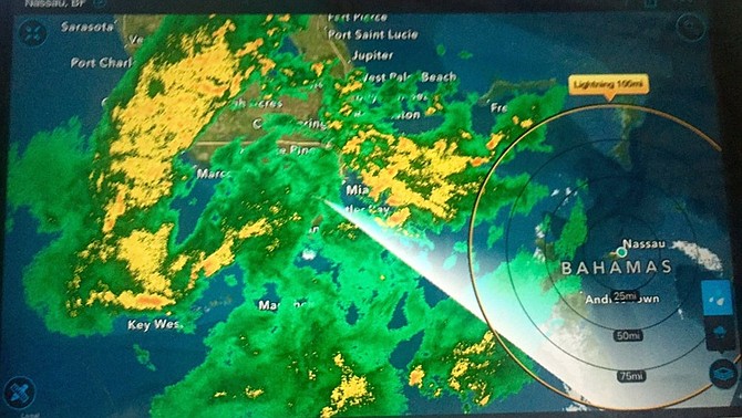
THE BULK of the "severe weather" expected to affect the Northwest Bahamas on Friday will be felt in Bimini, Grand Bahama, Abaco and the Berry Islands, according to forecaster Gregory Thompson.
Mr Thompson told the Tribune that New Providence is expected to experience light to moderate rain and isolated showers beginning at 1pm.
At 11am the Meteorological Office office sent out a severe weather warning for Bimini and Grand Bahama.
Mr Thompson said a cluster of well-organised thunderstorms is moving northeastward over the extreme northwest Bahamas. The thunderstorms are expected to be severe at times, causing strong, gusty winds, dangerous lightning, heavy downpours, hail and possible waterspout and tornadic activity.
Boaters in the warning area should seek safe harbour and residents in the warning area should stay indoors and away from windows as conditions worsen. Residents are also being warned not to seek shelter under trees or in water as they can become lightning conductors.
"The really bad weather will remain north of New Providence; there will be a break and then a second line of weather from across Florida will move across New Providence this afternoon into the evening," Mr Thompson said.
"The warning continues as there is quite a bit of activity coming from across Florida but New Providence will only experience maybe one or two strong showers."
All government schools in Andros, the Berry Islands, Grand Bahama and New Providence have been closed on Friday as the northwest Bahamas braces for severe thunderstorms and the possibility of flooding, waterspouts and tornadoes.
The Ministry of Education, Science and Technology issued the notice of closure at 7am on Friday "based on advice received from the Met Office".
Deputy Director of the Department of Meteorology, Basil Dean, said in a statement on Thursday afternoon that computer model analysis indicates that a pre-frontal trough will move across the northwest Bahamas beginning on Friday morning and “strong gusty winds in excess of gale force are also expected through Saturday night”.


Comments
John 8 years, 3 months ago
Getting a little taste of winter this weekend?
B_I_D___ 8 years, 3 months ago
Tribune...be careful with your reporting please...ALL GOVERNMENT schools...private schools are still open for the moment...or at least some of them are...
sansoucireader 8 years, 3 months ago
And COB, a government school, is still open too.
dred93 8 years, 3 months ago
They said Eleuthera as well on the Radio...
sheeprunner12 8 years, 3 months ago
MY God whats wrong with this government????........... putting people in a panic over a cold front??????? ........... may I remind this lousy government that there was a Cat 5 hurricane just 3 months ago in the southern Bahamas .........that they bungled big time?????
John 8 years, 3 months ago
The greatest losers in this whole affair was the school lunch vendors who had to give away or dump thousands of dollars in prepared lunches. Had it not been a weekend they may could have salvaged some of it but better to err on the side of caution..I guess
ThisIsOurs 8 years, 3 months ago
Actually, the MET office seems to have gotten this right, the decision to close schools came from Min. Of Education..."Thompson told the Tribune that New Providence is expected to experience light to moderate rain and isolated showers beginning at 1pm..... The really bad weather will remain north of New Providence; there will be a break and then a second line of weather from across Florida will move across New Providence this afternoon into the evening," Mr Thompson said."
Sign in to comment
Or login with:
OpenID