Thursday's updates on Hurricane Irma will now appear HERE
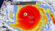
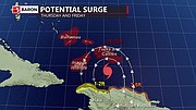
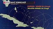
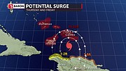
7.30pm UPDATE: Baron Weather has produced this GFS prediction of wind and pressure (right), a GOES-16 view of the storm (below left) and a diagram of potential surge (below right).
4.10pm UPDATE: The Cabinet Office has released the following statement on the closure of government offices: “Due to the proximity of Hurricane Irma and the forecasted weather associated with the storm, the Cabinet Office announced the closure of all Government offices, except for essential services, at 5:00 p.m. today, Wednesday, 6 September, 2017 until further notice. Based on the intensity of the storm residents are advised to heed the warnings issued by the National Emergency Management Agency (NEMA) and the Department of Meteorology, and stay tuned for further updates.”
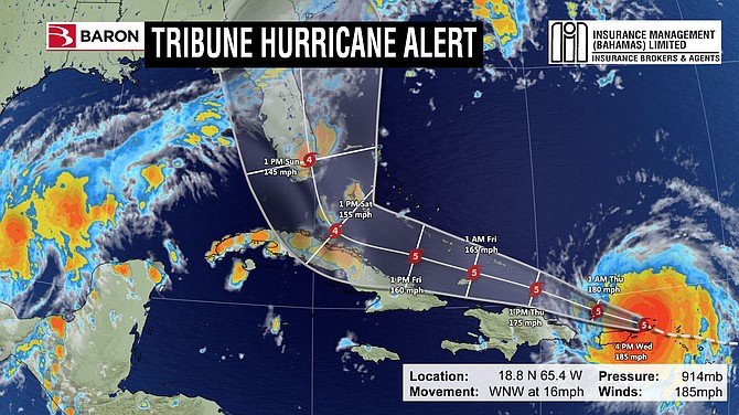
2.20pm UDPATE: Baron Weather has released this new tracking map for Hurricane Irma (main picture - mobile users click HERE) and this update: “Over the past 24 hours there has been a significant shift back to the east with both the forecast models as well as the official NHC track. This puts the western islands of the Bahamas (Andros, Grand Bahama and especially Bimini) at a greater danger to experience potentially major hurricane conditions. The NHC track, the GFS, the European model and the UKMet model all now have similar paths for Irma which have the center of the storm approaching Miami on Sunday morning and then traveling up the east coast of Florida through the day on Sunday and Monday. This will be a long duration storm since it will be affecting the southern islands late Thursday and Friday and affect the central islands on Friday and Saturday and then the western islands late Saturday and Sunday. All models and the NHC are indicting a Category 4 storm as it moves northwestward and then northward over the next 4-5 days.”
Baron has also supplied this GOES-16 satellite footage of the storm: (LINK for mobile users)
http://youtu.be/3E3DmyLAtHA
11.15am UPDATE: The Royal Bahamas Defence Force has been preparing beds for the evacuees in New Providence. (Video LINK for mobile users)

Video LINK for mobile users.
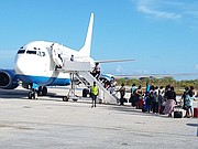
10.15am UPDATE: Evacuation flights are arriving in Nassau.
By KHRISNA RUSSELL
Deputy Chief Reporter
krussell@tribunemedia.net
DELIVERING the “strongest plea possible,” Prime Minister Dr Hubert Minnis appealed to residents of Mayaguana, Inagua, Crooked Island, Acklins, Long Cay and Ragged Island to evacuate their respective areas, stressing emergency personnel and assistance will not be available during the immediate impact of “potentially catastrophic” Hurricane Irma.
During a national address last night, the prime minister, pictured, warned southern island residents “not (to) be foolish and try to brave out this monster storm,” adding the price for not evacuating may be a life or serious physical harm.
As the country faces what could be the most severe natural disaster in the modern history of The Bahamas, Dr Minnis said because of the possible loss of life associated with the category five storm, a voluntary evacuation of vulnerable communities has been put in place.
This is the largest evacuation in the history of the country, Dr Minnis said.
Irma, according to US Accuweather forecaster Dan Kottlowski, now has winds of 185mph, making it a solid category five storm.
Officials have said the southern islands will begin to feel Irma’s impact by Thursday evening continuing into Friday.
The central and northern Bahamas will also likely experience effects of the storm as it churns through the country into the weekend.
“We are advising in the strongest possible terms that the residents of MICAL and Ragged Island comply with the evacuation from their respective islands,” Dr Minnis said, flanked by members of Cabinet and other government officials at his office on West Bay Street.
“Let me be very clear: those who refuse to evacuate, place themselves in potentially great danger from this monster hurricane, including from dangerously strong and high storm surges, which is one of the greatest threats from a hurricane.
“Emergency personnel and assistance will be unavailable during the immediate impact of the hurricane for those in MICAL and Ragged Island who do not evacuate.
“Furthermore, rescue and recovery may take an extended period of time for those who did not evacuate.”
He continued: “Let me again make the strongest plea possible to the residents of MICAL and Ragged Island to evacuate their respective areas.
“Do not put your life and those of your loved ones at unnecessary risk. Do not be foolish and try to brave out this monster storm. The price you may pay for not evacuating is your life or serious physical harm.”
Mr Kottlowski told The Tribune yesterday the southern islands will likely feel the worst of the storm on Friday.
He warned Bahamians to continue preparing for a “pretty strong situation.”
“Right now, Irma is moving on a west at 14 mph and has winds of 185mph which makes it a solid category five hurricane,” Mr Kottlowski said.
“It ties as the second strongest hurricane in the Atlantic so it will continue to track over the northern portion of the Leeward Islands tonight (Tuesday) and early tomorrow (Wednesday) and pass very close to the Virgin Islands (Wednesday) and north of Puerto Rico (today) and (tonight).
“It will start to impact the Turks and Caicos as we head into Thursday with tropical storm force winds.
“It’s now looking like the centre of Irma is probably going to pass just south of the Turks and Caicos Thursday night and Friday. However, they are still going to be on the north and east side of the hurricane, which is where typically the strongest winds are, so they can still expect to see hurricane conditions and very, very heavy rainfall. This again is going to start to happen late Thursday or Thursday night and the worst conditions in the Turks and Caicos and the southern Bahamas will generally be centred on Friday.”
He continued: “Now looks like the storm is going to track probably Friday night and Saturday but it will still bring high winds and very rough surf and very heavy rainfall into the central Bahamas Friday night into Saturday and those hurricane conditions will then potentially spread into the northern Bahamas Saturday night into Sunday morning.
“Right now, the way we are looking at it right now it does look like the centre of the storm will pass south and west of the Bahamas. So the Bahamas will be on the eastern portion of the hurricane, which again is the side that has the strongest winds and again can create the terrible surf and so forth.
“So just because the centre of the storm is not going to track right over the Bahamas it doesn’t mean that we need to let our guard down because again conditions are going to be pretty bad especially over southern Bahamas during Friday. Central and northern Bahamas again are going to have sustained winds of 39mph to 70mph with wind gusts over 74mph during Saturday growing and building into Sunday.
“So people should still prepare for a pretty strong situation,” he said.
Evacuations
Evacuations from the southern islands will begin early Wednesday morning and are expected to be complete by this evening.
The prime minister said those who agree to evacuate should secure and bring identification with them, including passports, NIB and voter’s cards along with medication, clothing and toiletries sufficient for several days.
He said those who agree to evacuate should contact relatives, friends and church fellowships to accommodate them during their stay in New Providence.
For anyone without these kinds of accommodations, Dr Minnis said the Kendal Isaacs National Gymnasium will be used as a major shelter for those evacuated from MICAL and Ragged Island.
The Roman Catholic Archdiocese has also generously agreed to the use of Loyola Hall on Gladstone Road as a major shelter, he said. These centres will be adequately staffed by various personnel, and will be secured by the Royal Bahamas Police Force.
“We are working to ensure that the evacuations are completed as efficiently and as orderly as possible given the circumstances at hand and the possibility of the hurricane taking a different path than currently forecast.
“We are receiving constant updates on the location and the potential impact of Hurricane Irma. We are also closely monitoring Tropical Storm Jose, which may develop into a hurricane by Friday.”
The prime minister said this is now the time for national unity.
“In this spirit, I have briefed the Leader of the Opposition (Philip ‘Brave’ Davis) on Hurricane Irma. I have also invited the leader of the opposition to join me at the Office of the Prime Minister during the preparation for Hurricane Irma, and to offer his advice as the country faces the threat posed by this monster hurricane, including during the rescue and recovery stages after the storm passes.”
While extending prayers, best wishes and solidarity to Bahamians and the country’s CARICOM partners, Dr Minnis called on the generosity of Bahamians, at home and abroad, and residents, to offer whatever they can in terms of volunteerism, monetary and other resources to help those affected by Hurricane Irma.
He also appealed to Bahamians to refrain from re-sending social media posts which appear questionable or false.


Comments
John 6 years, 7 months ago
Abaco and Grand Bahama is now back in the cone
Well_mudda_take_sic 6 years, 7 months ago
Whisper has it both Moody's and S&P made decision late yesterday afternoon to downgrade Bahamas a couple of notches if Hurricane Irma hits our main developed islands - New Providence, Grand Bahamas, Abaco, Exumas and Eleuthera.
ThisIsOurs 6 years, 7 months ago
Good, they're out of apocalypse zone.
John 6 years, 7 months ago
There is reportedly a shortage of bottled water in New Providence. Come on Water and Sewerage do your job. If you cannot find bottled water before the storm fill your containers with tap water. While it is still running. Then you can use this water for cooking and other stuff and use the bottled water you do have for drinking. and if worse comes to worse you can boil and use tap water for drinking. Better than having nothing at all.
tell_it_like_it_is 6 years, 7 months ago
Super Value Mackey st had lots of bottled water (5 gallon) this evening including Aqua Pure and other brands.
TalRussell 6 years, 7 months ago
Comrades! What precautions are being taken to secure the left alone properties, valuables, belongings, boats and vehicles, from the potential thieves and vandals, and being an animal lover - what is being done to ensure the safety and care for the many domestic and backyard hobby farm animals on the evacuated islands in hurricane's path?
ThisIsOurs 6 years, 7 months ago
If this plan was truly "proactive" like everyone is throwing that word around, all of that could have been taken into consideration. There's no securing boats and vehicles in the path of a cat 5. You move them or they're damaged. Hopefully animals can find shelter somewhere. If anyone tries to take advantage of the situation I hope Irma give them what they looking for.
Tam30 6 years, 7 months ago
What about the Biminites? We are the smallest island and right on the Atlantic ocean.
sheeprunner12 6 years, 7 months ago
Soooooo, will they evacuate Bimini and GB as well??????? ......... To Eleuthera????????
John 6 years, 7 months ago
New Providence and Andros should have at least 4-5 days of water and supplies on hand. Simply because the hurricane is expected to make the turn to the North just after it passes over Andros. So this will mean Andros/ new providence will get a second set of strong winds and most business may remain closed
John 6 years, 7 months ago
Who is watching Jose? It seems to want to follow the track of Irma and even though it is a smaller storm it has the potential to impact the North East Bahamas, shortly after Irma.
ThisIsOurs 6 years, 7 months ago
They say it's going out to sea, not a threat
tell_it_like_it_is 6 years, 7 months ago
So far, Jose is not expected to impact The Bahamas... Bermuda is more likely and I pray it continues to keep far from us. It is already traveling WNW so it is expected to turn earlier, when Irma traveled W for quite a while before changing.
https://weather.com/storms/hurricane-...">https://weather.com/storms/hurricane-...
ThisIsOurs 6 years, 7 months ago
OMG Antigua and Barbuda's PM is reporting total destruction on Barbuda, says 100% of homes destroyed, vehicles damaged. uninhabitable. Not sure what their building codes are like. Says Antigua was spared the worst of the storm
Any "slightly touched" people on Inagua who believe they're "protecting" their homes, please leave
tell_it_like_it_is 6 years, 7 months ago
CNN reports 90%+ for Barbuda, I did not get stats on Antigua. I don't things are as bad on Antigua because they are a bit further south.
http://edition.cnn.com/2017/09/06/ame...">http://edition.cnn.com/2017/09/06/ame...
John 6 years, 7 months ago
Jose is following Irma and keeps dropping closer to the Caribbean
John 6 years, 7 months ago
Ninety Five Percent of the homes have been demolished by Irma. The island has been declared uninhabitable. Survivors are being transported to nearby island of Antigua
The_Oracle 6 years, 7 months ago
Evacuating MICAL is a smart move, consider evacuating West End into Freeport also. Those poor peeps ain't barely recovered from Matthew! Also Beware Fake news, apparently natural disasters are subject to it as much as political crap!
John 6 years, 7 months ago
South Andros may need to be evacuated as tint only will the eye wall pass over there but the storm will be over Andros almyfour days as it makes a Northerly turn. Can persons go North rather than everyone coming to New Providence
John 6 years, 7 months ago
Under the present track the entire pan handle of Florida will be impacted. There will be storm surge From the Keys all the way up on the Eastern seaboard. With current track of Irma and current conditions damage to Florida can exceed $300 Billion!
John 6 years, 7 months ago
Some of the same islands devastated (Flattened) by Irma are expected to get hit by Jose. Barbadua has no airport no port no hospital and it may hit. Turks and acacias may get surge up to 20 feet meaning the island will be completely covered. Surge will also be a factor for a Kline crooked island and mayaguana
John 6 years, 7 months ago
Irma has picked up forward speed. Now tractate 17 mph. Speed may help the storm to weaken
OldFort2012 6 years, 7 months ago
What are you all worried about? With the number of Bishops, Reverends, Popes, Archdeacons and Cardinals in the Bahamas and all praying at once, it is almost impossible for anything bad to happen here! Surely!
ashley14 6 years, 7 months ago
lol
OldFort2012 6 years, 7 months ago
I am told Government Offices are closed today. Can anyone tell the difference? Things seem to progress at usual pace!
ashley14 6 years, 7 months ago
It is weird that the government offices are closed. Right now they should be working overtime for the people already hit by Irma. Where there are shortages of water and food, figuring out how to bring more in. In the States they would never be elected again. They are responsible for the preparation and the aftermath.
ashley14 6 years, 7 months ago
Coming home from work the news was reporting that Irma has shifted to the West.
Sign in to comment
Or login with:
OpenID