A WEATHER official is urging residents to monitor the progression of Tropical Depression Eta, which could develop into a tropical storm by Friday.
Chief Climate Officer Greg Thompson said the system may bring unsettled weather and possible tropical storm conditions for parts of The Bahamas—including Andros and Bimini— Sunday or Monday.
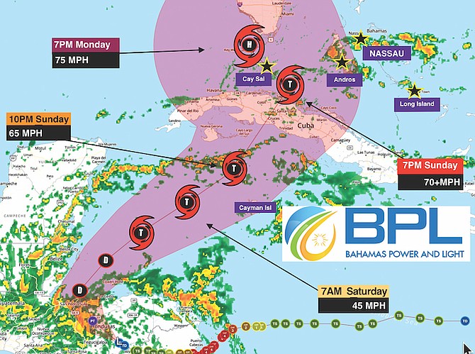
“The National Hurricane Centre anticipates it moving back off shore by either late this evening (Thursday) or into Friday. It is expected to regain some strength and develop back into a tropical storm,” the chief climate officer said.
“The National Hurricane Centre then expects it to move towards the north and east and approach southeastern, southwestern Cuba by late Friday and into Saturday. Thereafter, the system will move into the Florida Straits which will put it west of The Bahamas near the Florida Keys and somewhere near south Florida – that will be Saturday into Sunday.
“Sunday into Monday the system is expected to be just north of Cuba into our area or just west of The Bahamas… Thereafter it is expected to make a turn towards the west, Monday into Tuesday, and be moving away from The Bahamas.
“So between Sunday and Monday, parts of The Bahamas will be in the cone of uncertainty. During that timeframe we are expected to experience unsettled weather and possibly tropical storm conditions only for those areas.”
He added that the NHC doesn’t have a real handle on the system’s intensity or how strong it’s expected to develop. Yet, regardless of development, parts of the Bahamas will be experiencing showers and thunderstorms as the system approaches the country from the west during the timeframe of Sunday/Monday into early Tuesday.


Comments
Use the comment form below to begin a discussion about this content.
Sign in to comment
Or login with:
OpenID