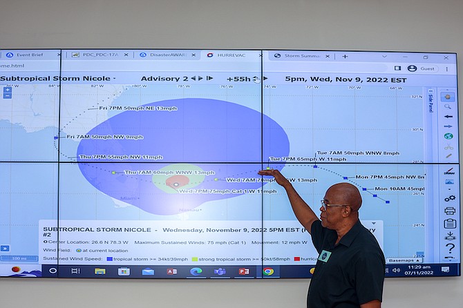
Arnold King, Chief Meteorological Officer at Bahamas Department of Meteorology, gives an update on the storm on Monday. Photo: Austin Fernander
MONDAY 8.10pm UPDATE: With Grand Bahama bracing for hurricane conditions on Wednesday, residents of West End and East End are advised to evacuate as soon as possible as coastal flooding between three to six feet is expected. The island should begin to experience tropical storm conditions by Tuesday evening – full story HERE.
With Grand Bahama and Abaco projected to take a “direct hit” from Subtropical Storm Nicole, Acting Prime Minister Chester Cooper urged residents in low lying areas and those in compromised structures to evacuate. He said law enforcement officials will be providing evacuation assistance before the storm, but stressed that once conditions deteriorate, emergency responders will be “constrained” to provide help until the all clear is given – full story HERE.
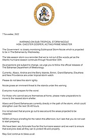
ALERT #6 ON SUBTROPICAL STORM NICOLE ISSUED BY THE BAHAMAS DEPARTMENT OF METEOROLOGY AT 8PM EST, MONDAY 7TH NOVEMBER, 2022.
...NICOLE EXPECTED TO STRENGTHEN TUESDAY NIGHT AND WEDNESDAY…
...TROPICAL STORM CONDITIONS EXPECTED TO BEGIN TUESDAY NIGHT OVER THE NORTHWEST BAHAMAS…
A HURRICANE WARNING IS NOW IN EFFECT FOR THE ISLANDS OF GRAND BAHAMA, ABACO, BIMINI, AND THE BERRY ISLANDS.
A HURRICANE WARNING MEANS THAT HURRICANE CONDITIONS COULD BE EXPERIENCED IN THE ABOVE MENTIONED ISLANDS WITHIN 36 HOURS.
A TROPICAL STORM WARNING IS NOW IN EFFECT FOR THE ISLANDS OF ELEUTHERA, NEW PROVIDENCE AND ANDROS.
A TROPICAL STORM WARNING MEANS THAT TROPICAL STORM CONDITIONS COULD BE EXPERIENCED IN THE ABOVE MENTIONED ISLANDS WITHIN 36 HOURS
AT 7 PM EST, THE CENTER OF SUBTROPICAL STORM NICOLE WAS LOCATED NEAR LATITUDE 26.7° DEGREES NORTH AND LONGITUDE 70.8° DEGREES WEST, OR ABOUT:
385 MILES EAST OF HOPE TOWN, ABACO
435 MILES EAST OF EAST END, GRAND BAHAMA
360 MILES EAST-NORTHEAST OF GOVERNOR’S HARBOUR, ELEUTHERA
420 MILES EAST-NORTHEAST OF NEW PROVIDENCE
465 MILES EAST-NORTHEAST OF NICHOLL’S TOWN, ANDROS
AND 515 MILES EAST OF ALICE TOWN, BIMINI.
NICOLE IS MOVING TOWARD THE NORTHWEST NEAR 8 MPH AND THIS GENERAL MOTION IS EXPECTED TO CONTINUE THROUGH TONIGHT. A TURN TOWARD THE WEST OR WEST-SOUTHWEST IS FORECAST TO BEGIN ON TUESDAY AND THAT MOTION SHOULD CONTINUE THROUGH EARLY THURSDAY.
ON THE FORECAST TRACK, THE CENTER OF NICOLE WILL APPROACH THE NORTHWEST BAHAMAS ON TUESDAY AND TUESDAY NIGHT, MOVE NEAR OR OVER THOSE ISLANDS ON WEDNESDAY AND APPROACH THE EAST COAST OF FLORIDA WEDNESDAY NIGHT.
MAXIMUM SUSTAINED WINDS ARE NEAR 45 MPH WITH HIGHER GUSTS. SOME SLIGHT STRENGTHENING IS FORECAST TONIGHT OR TUESDAY, WITH A FASTER RATE OF STRENGTHENING EXPECTED TUESDAY NIGHT AND WEDNESDAY. NICOLE IS FORECAST TO BE AT OR NEAR HURRICANE INTENSITY BY WEDNESDAY OR WEDNESDAY NIGHT WHILE IT IS MOVING NEAR OR OVER THE NORTHWEST BAHAMAS.
WINDS OF 40 MPH EXTEND OUTWARD UP TO 310 MILES FROM THE CENTER.
STORM SURGE COULD RAISE WATER LEVELS BY AS MUCH AS 4 TO 6 FEET ABOVE NORMAL TIDE LEVELS ALONG THE IMMEDIATE COAST IN THE NORTHWEST BAHAMAS.
NICOLE IS EXPECTED TO PRODUCE RAINFALL AMOUNTS OF 2 TO 4 INCHES WITH LOCALIZED HIGHER AMOUNTS OF UP TO 6 INCHES, ACROSS THE NORTHWEST BAHAMAS TUESDAY THROUGH THURSDAY.
THE FORMATION OF WATERSPOUTS AND TORNADOS ARE POSSIBLE DURING THE PASSAGE OF NICOLE THROUGH THE BAHAMAS.
PREPARATIONS TO PROTECT LIFE AND PROPERTY SHOULD BE RUSHED TO COMPLETION. RESIDENTS IN THE NORTHWEST BAHAMAS SHOULD PREPARE FOR TROPICAL STORM CONDITIONS BEGINNING TUESDAY NIGHT. RESIDENTS ON THE ISLANDS OF GRAND BAHAMA, ABACO, BIMINI AND THE BERRY ISLANDS SHOULD ANTICIPATE HURRICANE CONDITIONS BEGINNING EARLY WEDNESDAY MORNING.
INTERESTS IN THE CENTRAL BAHAMAS SHOULD CONTINUE TO MONITOR THE PROGRESS OF NICOLE.
12.30pm UPDATE: WARNING ON SUB-TROPICAL STORM NICOLE FROM ACTING PRIME MINISTER CHESTER COOPER
“The Government is closely monitoring Subtropical Storm Nicole which is projected to be in The Bahamas by Wednesday.
“The late-season storm is a reminder that we’re not out of the woods yet as the Atlantic hurricane season continues through November 30th.
“As projections are subject to change, we urge you to follow the official releases of The Bahamas Department of Meteorology.
Currently, Abaco, Andros and the Berry Islands, Bimini, Grand Bahama, Eleuthera and New Providence are under tropical storm watch.
“Please do not take this storm lightly.
“Nicole poses an imminent threat to the islands under the warning.
“Everyone must prepare for the worst.
“For those who cannot secure themselves at home, please make preparations to move to the nearest storm shelter. Abaco and Grand Bahama are currently directly in the path of the storm, which could strengthen over the next 36-48 hours. It is not advised that anyone go out to sea around the areas projected to be impacted.
“NEMA will have a briefing for the nation this afternoon, but I ask that you do not wait to start preparing.
“We have been very fortunate thus far this hurricane season and we want to ensure that everyone does all they can to protect life and property.
“May God continue to bless us all. ”
ALERT #2 ON SUBTROPICAL STORM NICOLE ISSUED BY THE BAHAMAS DEPARTMENT OF METEOROLOGY AT 8:00 AM EST, MONDAY 7TH NOVEMBER, 2022.
...NOAA HURRICANE HUNTERS ARE INVESTIGATING SUBTROPICAL STORM NICOLE…
...A PROLONGED PERIOD OF HAZARDOUS WEATHER IS EXPECTED OVER THE NORTHWESTERN BAHAMAS, FLORIDA, AND THE SOUTHEASTERN COAST OF THE UNITED STATES THIS WEEK...
A TROPICAL STORM WATCH REMAINS IN EFFECT FOR THE ISLANDS OF THE NORTHWEST BAHAMAS. THESE INCLUDE THE ISLANDS OF GRAND BAHAMA, ABACO, BIMINI, THE BERRY ISLANDS, ELEUTHERA, NEW PROVIDENCE AND ANDROS.
INTERESTS IN THE CENTRAL BAHAMAS SHOULD CONTINUE TO MONITOR THE PROGRESS OF NICOLE. ADDITIONAL WATCHES WILL LIKELY BE REQUIRED LATER TODAY.
A TROPICAL STORM WATCH MEANS THAT TROPICAL STORM CONDITIONS COULD BE EXPERIENCED IN THE MENTIONED ISLANDS WITHIN 48 HOURS.
AT 7:00 AM EST, THE CENTRE OF SUBTROPICAL STORM NICOLE WAS LOCATED NEAR LATITUDE 25.9° DEGREES NORTH AND LONGITUDE 69.1° DEGREES WEST, OR ABOUT 490 MILES EAST OF HOPE TOWN, ABACO, 510 MILES EAST OF EAST END, GRAND BAHAMA, 445 MILES EAST-NORTHEAST OF GOVERNERS HARBOUR, ELEUTHERA AND ABOUT 550 MILES EAST-NORTHEAST OF NEW PROVIDENCE.
NICOLE IS MOVING TOWARD THE NORTH-NORTHWEST NEAR 14 MPH. A TURN TOWARD THE NORTHWEST WITH A DECREASE IN FORWARD SPEED IS EXPECTED LATER TODAY. A WESTWARD OR WEST-NORTHWESTWARD MOTION IS FORECAST TUESDAY THROUGH EARLY THURSDAY.
ON THE FORECAST TRACK, THE CENTRE OF NICOLE WILL APPROACH THE NORTHWEST BAHAMAS ON TUESDAY, MOVE NEAR OR OVER THOSE ISLANDS ON WEDNESDAY AND APPROACH THE EAST COAST OF FLORIDA BY WEDNESDAY NIGHT.
MAXIMUM SUSTAINED WINDS ARE NEAR 45 MPH WITH HIGHER GUSTS.
GRADUAL STRENGTHENING IS FORECAST DURING THE NEXT FEW DAYS AND NICOLE COULD BE NEAR OR AT HURRICANE INTENSITY BY WEDNESDAY OR WEDNESDAY NIGHT WHILE MOVING NEAR THE NORTHWEST BAHAMAS.
WINDS OF 40 MPH OR GREATER EXTEND OUTWARD UP TO 275 MILES TO THE EAST OF THE CENTRE.
STORM SURGE COULD RAISE WATER LEVELS BY AS MUCH AS 3 TO 5 FEET ABOVE NORMAL TIDE LEVELS ALONG THE IMMEDIATE COAST ON THE NORTHWEST BAHAMAS.
NICOLE IS EXPECTED TO PRODUCE RAINFALL AMOUNTS OF 2 TO 4 INCHES, ACROSS THE NORTHWEST BAHAMAS TUESDAY THROUGH THURSDAY.
THE FORMATION OF WATERSPOUTS AND TORNADOS ARE POSSIBLE DURING THE PASSAGE OF NICOLE TROUGH THE BAHAMAS.
RESIDENTS IN THE NORTHWEST BAHAMAS SHOULD PREPARE FOR POSSIBLE TROPICAL STORM CONDITIONS BEGINNING TUESDAY NIGHT.
THE NEXT ALERT ON SUBTROPICAL STORM NICOLE WILL BE ISSUED AT 11:00AM EST.
MONDAY MORNING UPDATE 5AM:
..Subtropical Storm Nicole has formed northeast of the Bahamas...
...a prolonged period of hazardous weather is expected over the northwest Bahamas, Florida, and the southeastern coast of the United States this week...
A Tropical Storm Watch is now in effect for the islands of the Northwest Bahamas. this includes the islands of Grand Bahama, Abaco, Bimini, the Berry Islands, Eleuthera, New Providence and Andros.
A Tropical Storm Watch means that tropical storm conditions could be experienced in the mentioned islands within 48 hours.
At 4:00 am EST, the centre of Subtropical Storm Nicole was located near latitude 25.5 degrees north and longitude 68.5 degrees west, or about 526 miles east-southeast of Hope Town, Abaco, 592 miles east-southeast of East End, Grand Bahama, 478 miles east of Governers Harbour, Eleuthera and about 550 miles east of New Providence.
Nicole is moving toward the north-northwest near 14 mph. a turn toward the northeast with a decrease in forward speed is expected later today. a westward or west-northwestward motion is forecast Tuesday.
FROM EARLIER:
By LETRE SWEETING
lsweeting@tribunemedia.net
THE Department of Meteorology is warning residents of the northwest and central Bahamas to be on alert this week for possible flooding and heavy rain due to an approaching weather system near Puerto Rico that could develop into a hurricane today.
The statement issued yesterday afternoon said to expect strong winds and thunderstorms, should the system develop further into a tropical storm.
“The Bahamas Department of Meteorology is closely monitoring a low-pressure area north of Puerto Rico that is expected to become a tropical or subtropical storm tonight or Monday, as it moves north or northwestward over the southwestern Atlantic,” the statement said.
“There is the risk of widespread impacts from coastal flooding, large sea swells, gale-force winds, rough surf, rip currents and beach erosion along portions of the northwest and central Bahamas beginning in the early to middle of this week,” the statement said.
“The system could be at or near hurricane strength before it approaches the northwest Bahamas on Wednesday and Thursday bringing the potential for dangerous storm surge, damaging winds and heavy rainfall into the area.”
The statement continued: “Residents and interests in the northwest and central Bahamas should complete their seasonal hurricane preparations, if they have not already done so.”
The department said tropical storm and hurricane watches may be issued for these areas by early today.
Shezelle Mather, a forecaster at The Bahamas Department of Meteorology, urged people to pay close attention to the system.
“It still has the potential to develop anywhere between maybe tonight (Sunday) and tomorrow (Monday),” she told this newspaper.
“It could bring some strong gusty winds to the northwest and central islands and you’re looking at some showers and thunderstorms across the central and southeast Bahamas,” she said.
“If it does develop into a tropical system or disturbance and then after that it would be determined what kind of impact we’re likely to have.”
She added, “We encourage all Bahamians to pay close attention to the system.”
Last night, the Minister for Grand Bahama, Ginger Moxey, issued a statement, saying: “We are closely monitoring an area of Low Pressure which is a possible threat to Grand Bahama Island and surrounding cays. There is high chance of this system developing into a Tropical or Sub-tropical Storm over the next day.
“We strongly encourage all residents of Grand Bahama to make necessary preparations and pay careful attention to weather reports from the Bahamas Department of Meteorology. As advised by Met Department, Grand Bahama and surrounding cays are at risk for widespread impacts from coastal flooding, large sea swells, gale-force winds, heavy rainfall, rough surf, rip currents and beach erosion.
“Everyone should complete storm preparations, stay alert and follow The Bahamas Department of Meteorology for further updates.
“Let’s stay safe, take all necessary precautions, be our brother’s and sister’s keeper. Our prayers are with Grand Bahama, surrounding cays and all areas in the path of this potential Tropical or Sub-tropical storm.
“We remain Grand Bahama Strong.”
In September, with many homes still being repaired after the devastation left by Hurricane Dorian in 2019, many Family Island residents braced for the impact of Tropical Storm Fiona, which passed through the southern islands and Hurricane Ian, which passed through the northwest and central islands.
Though the impact of these systems was mild, many residents remain vigilant.
Hurricane season runs June 1 through November 30.


Comments
bahamianson 1 year, 5 months ago
Yeah, students get off at noon. Who will pivk them up and mind them? Parents must be at work. Who will put up the shutters if the parents are at work until 5pm? Will the children put the shutters up. So please stop telling people to prepare.the government does not give you time to do so. Go to work.
ThisIsOurs 1 year, 5 months ago
"Everyone must prepare for the worst"
Wrong. "Everyone" should not prepare for the worst. Some "maybe" should prepare for the worst. Some should prepare for inconvenience. Some should be ready to offer assistance if needed. Who should prepare for the worst and who should be preparing to assist requires data on who is likely to be impacted and how severely. Will we have a significant storm surge? What does 3-5 ft look like? Does that come on shore? Where? Is it on all northern islands is it any island? What dies 2-4" of rain look like and where?
This EVERYBODY PANIC messaging Ive been hearing all day is NOT disaster preparedness. Couldnt believe people in Nassau were rushing grocery stores. Its ridiculous. Yes anything could happen in a day but so far, just like Fiona, the data is saying something completely different from the panicky interpretation
Commenting has been disabled for this item.