
A TROPICAL STORM WARNING REMAINS IN EFFECT FOR THE ISLANDS OF GRAND BAHAMA & BIMINI .. RAIN BANDS FROM HURRICANE IAN WILL CONTINUE TO AFFECT NORTHWEST AND CENTRAL BAHAMAS THROUGH FRIDAY..
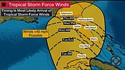
RESIDENTS IN GRAND BAHAMA AND THE BIMINIS SHOULD PREPARE FOR THE POSSIBILITY OF SUSTAINED TROPICAL STORM FORCE WINDS BEGINNING THIS AFTERNOON THROUGH TO THURSDAY. RESIDENTS IN THE REMAINDER OF THE NORTHWEST BAHAMAS, INCLUDING ABACO, BERRY ISLANDS, ANDROS, NEW PROVIDENCE AND ELEUTHERA, COULD EXPERIENCE WINDS GUSTING TO GALE-FORCE DURING THAT PERIOD.
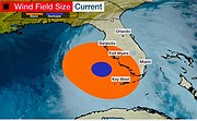
Ian has strengthened into an extremely dangerous Category 4 Hurricane with Maximum sustained winds of 140mph.. expected to cause life threatening storm surge, catastrophic wind and flooding damages to the Florida peninsula
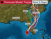
At 5 AM, Ivan was located 75 miles west- southwest of Naples, Florida, or 225 miles West of Alice Town Bimini, or 310 miles southwest of Nicholl’s Town, Andros, or 270 miles SW of West End, Grand Bahama, or 350 miles WSW of New Providence. Ian has jogged a little to the left this morning, but the longer-term motion remains north-northeastward or 015 degrees at 9 kt. The hurricane should continue moving north-northeastward through Thursday between the western side of a subtropical ridge and a broad trough over the eastern United States. This motion is expected to bring the centre of Ian onshore along the west coast of Florida later today, crossing over central Florida tonight and Thursday before turning northward along coast of northeastern Florida and Georgia Thursday and Friday.
FORECAST FOR NW BAHAMAS FROM BAHAMAS DEPT OF METEOROLOGY
Due to its large expanse and the fact that the islands are located on the strongest side of the storm, rainbands from Hurricane Ian will continue to bring heavy rains, severe thunderstorms with dangerous lightning, gusty winds and possible tornadic activity to the Northwest Bahamas in particular the islands of Bimini, Grand Bahama, Abaco, the Berry Islands and Andros.
For the extreme Northwest Bahamas (Bimini, Grand Bahama, the Berry Islands and Abaco their surrounding waters and Cays), winds are forecast to reach near gale force (28 to 33 knots) with gusts to tropical storm force beginning Wednesday AM.
Total rainfall amounts of 4 to 6 inches, are expected with isolated amounts of up to 8
inches through Friday. As a result, severe localized flooding is possible in low-lying, and flood prone areas. Minor coastal flooding along the east and south coasts is possible during the high tide cycle.
Residents are advised to exercise extreme caution while moving about
MARINE
Mariners and boaters in these area, are to remain in port and beachgoers are advised to refrain from entering rough seas
SPECIAL NOTE
The public is reminded storms DO NOT move in a straight lines, they tend to wobble. Therefore, a state of readiness should be maintained in the event the Ian tracks farther east. Severe Thunderstorm Warnings will be issued, when required, throughout the day and into Friday.
Residents are advised to pay close attention to all warnings/statements issued by The Bahamas Department of Meteorology.


Comments
Use the comment form below to begin a discussion about this content.
Sign in to comment
Or login with:
OpenID