WEDNESDAY MORNING UPDATE:
By TANYA SMITH-CARTWRIGHT
tsmith-cartwright@tribunemedia.net
CHIEF Meteorologist Basil Dean predicted heavy rainfall starting as early as today due to a disturbance in the Atlantic Ocean – which has since developed into Tropical Storm Fred.
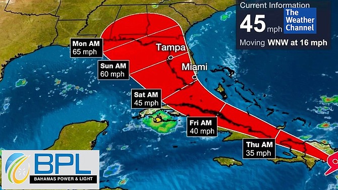
A tropical storm watch is currently in effect for the southeast Bahamas.
This includes Inagua, Mayaguana, Acklins, Crooked Island, Samana Cay, Long Cay and Ragged Island and the Turks and Caicos Islands.
A tropical storm watch means that tropical storm conditions could be experienced in the mentioned islands within 48 hours.
Residents in the mentioned areas should begin making preparations for the possibility of a tropical storm. Low lying areas should also prepare for heavy rainfall of up to four inches.
Mr Dean said: “It’s approaching. How much of it we will get is a bit too early to say other than we certainly will see a significant increase in rainfall beginning on Wednesday evening, Wednesday night, for the southeast Bahamas.
“Those rains should spread into the central Bahamas by Thursday afternoon. On Thursday night through Friday, the northwest Bahamas will also see an increase in rainfall as well.”
The disturbance was expected to pass near or over the US Virgin Islands and Puerto Rico late yesterday and then pass near or over Hispaniola today before making its way towards the southeastern Bahamas and the Turks and Caicos Islands on Thursday.
The storm is moving toward the west-northwest near 18 mph with maximum sustained winds near 35 mph, according to the US National Hurricane Centre.
In terms of what impact this disturbance could have on the country, Mr Dean said, “It all depends on what happens with the system crossing Hispaniola. Should that weaken… that is what we would like to see, but in the worst-case scenario a tropical storm should pass either to the south or slightly to the west of us.
“Winds should be anywhere from 40 miles per hour up to about maybe 60 miles per hour at the core. So what we will be monitoring is how close it comes to us. We can expect some heavy rainfall out of this system whether it develops or not, but in the worst-case scenario we are looking at a tropical storm sometime between Wednesday and Friday.”
He added: “I see there is another strong tropical wave that just came off the coast of Africa. That seems to be a little organised in terms of showers and thunderstorm activity. We should remember that we are heading into the middle of August and statistically this is the peak of the hurricane season so you can expect an increase in the frequency of these systems heading our way.”
Local, regional and global disaster managers and planners have noted that while the Atlantic Hurricane Season officially begins annually on June 1, the season “historically ramps up” in August.
Earlier this week, the National Emergency Management Agency (NEMA) said it was on alert due to the disturbance.


Comments
Use the comment form below to begin a discussion about this content.
Sign in to comment
Or login with:
OpenID